Dig We Must (Problem)
A Decision Game from 1921
In the spring of 1921, Major Ralph S. Keyser prepared the following problem for use at the Marine Corps Schools in Quantico, Virginia. Based upon events that took place during the First World War, it may contain elements that reflect Major Keyser’s opinions about the way that things should have done.
The exercise differs from conventional map problems of its day in asking students to engage it from the perspectives of three protagonists: the battalion commander, the company commander charged with digging the new line, and the company commander charged with protecting the Marines doing that work.
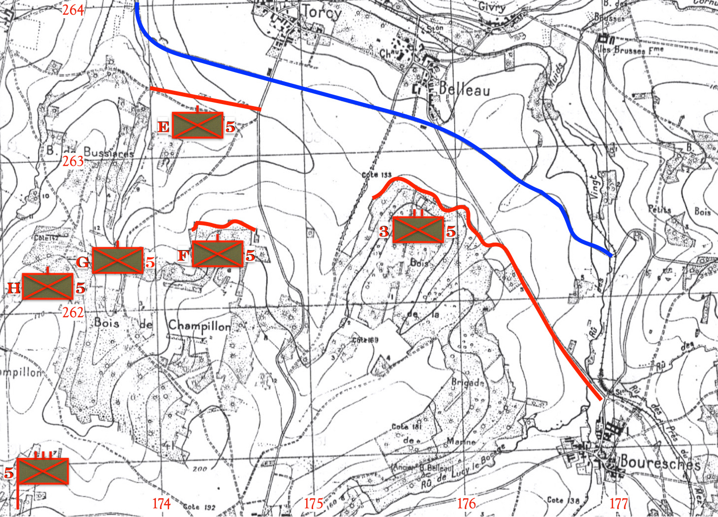
The sketches used to illustrate this post are taken from the (somewhat larger) map provided to the students who worked through the problem in 1921. The latter map, in turn, owed a lot to the French plan directeur used by Marines during the battle for Belleau Wood. (The fact that Bois de la Brigade Marine has replaced Bois de Belleau indicates that it dates from a time after the battle.)
In keeping with the customs and traditions of the Tactical Notebook, readers are invited to use the comments section to offer their own solutions.
General Situation
The 4th Brigade, 2nd Division, is holding the general line points (174.0-263.45) - edge of woods from point (174.3-262.6) to (174.6-262.4) - edge of Bois de la Brigade de Marine from points (175.4) to Bouresches exclusive.
At 5:00 PM, 25 June, ‘18, the 3rd Bn., 5th Marines, completed the final capture of the Bois de la Brigade de Marine and was consolidating a new line along the northern edge of that wood. The 2nd Bn., 5th Marines, commanded by Major A., was holding the centre to the westward of the Bois, disposed as follows:
Bn. CP [command post] at points (174.0-261.5); Co. E from points (174.0-263.45)-(174.7-263.3); Co. F edge of woods from points 9174.3-262.6) to (174.6-262.4); Co. G in reserve in woods at points (173.7-262.4) and Co. H in reserve at points (174.7-262.0). The enemy is holding the general line along improved road 500 meters south of Torcy and Belleau.
Special Situation
At 7:00 PM, 25 June ‘18, Major A Commanding 2nd Bn., 5th Marines, receives the following written message from Regt. HQ.:
5th Marines,
La Voie du Chatel Farm
25 June, ‘18, 6:30 PM
Message No. 206
To CO, 2nd Bn., 5th Marines:
(By runner.)
“The attack of 3rd Bn. [5th Marines] was a complete success. You will under cover of darkness tonight push your front line forward from the road fork at point (174.6-263.2) to connect up with the 3rd Bn.’s new line just east of Double Tree Road at point (175.45-262.8).1 The Artillery will put on a slow rate interdiction fire on the enemy’s lines on our from from 10:30 PM until you report the work completed.”
N
Col.
Required:
Major A’s action and orders
Captain B’s (the CO of Company detailed to dig the new line) action and orders
Captain C’s (the CO of Company detailed to furnish protecting patrols) action and orders.
The sun will set this evening at 10:00 PM. The sun will rise tomorrow at 5:49 PM. The moon, which will rise at 11:20 PM, will be full.
This exercise presumes that the Marine infantry battalions possess, as they did in 1918, four large rifle companies, each with six officers, two hundred and fifty-two men, and sixteen automatic rifles, but no proper (tripod-mounted) machine guns.
In keeping with the customs and traditions of the Tactical Notebook, readers are invited to use the comments section to offer their own solutions.
The solution composed by Major Keyser will be published on Friday, 24 November 2023.
For Further Reading:
The version of the problem published in the Marine Corps Gazette gave a grid reference of (175.45-162.8). However, as this makes no sense on the map, I presume that the “1” in “162.8” was a typographical error.


I’m stealing a D7 from the Engineers, unless I get caught then I’m in the Brig. have fun.
This grid coordinate has an error: Double Tree Road at point (175.45-162.8)... the northing should be 262.8.
That mission would suck. Following TLP instead of a proper 5 paragraph opord:
1.acknowledge mission was received
2. Issues WARNO to all companies, dispatch runner from S1 to 3/5 Marines to coordinate tie-in with their extreme left
3. Tentative plan:
Company G will fall into Compnay E trenches using the most concealed route, prepare for work, which commences at 2023 and ceases at Full moon rise when Germans can see the work. Trench to be waist deep and all spoil thrown to the front. Dig direction 100 degree to easting 175 then turn and dig 113 degrees toward Company F
Company F will proceed south west to the narrow draw adjacent to the 3/5 Marines a wait for darkness. After dark, the company will descend the draw, link up with 3/5 and our S1 runner and begin work immediately digging azimuth 295 toward Company G position and taking care to remain behind the concealing spur terrain feature to the north. Trench is to be waist deep only and all spoil to the front.
Company H will fall in on Company F positions and remain in overwatch/reserve.
The Battalion XO will relocate the HQ to ~174.6-261.7 in the woods behind Company H.
The Battalion Commander will conduct a leader recon and meet the Company F commander after dark near the 3/5 trenches.
The Sergeant Major will ensure all spades and pick are issued. Field telephone lines will be pre positioned immediately.
4. necessary Movement begins immediately
5. The Battalion commander and the operations office will reconnoiter the Company F digging area. The operations office will return to company F with any FRAGO.
6,7,8 The final order will be issued at 2100. if no orders are received by 2110, continue the mission