

Pashuga
The Second Problem of 'Snow'

The following post poses the second problem of a decision-forcing case. For the first two parts of this exercise, please see …


If you are new to decision-forcing cases, you may want to read …

While you search for the best location for the ‘small cauldron’ that you have been ordered to create, the commanding general of your division (the 3rd Motorized Infantry Division) solves the problem. Within minutes of appointing you to command of Security Unit Mollenhauer, he orders you to attack the Soviet forces in the village of Pashoga.
The general’s decision owes much to the operational situation in which his division finds itself.
Pashoga can be found on the west side of a bend in the Ugra. At present, thick ice covers the surface of that river. When, however, that ice melts, it will become an obstacle to movement. In particular, when it starts to flow again, the Ugra will complicate any Soviet offensive aimed at cutting off, from the south, German forces east of Vyazma.
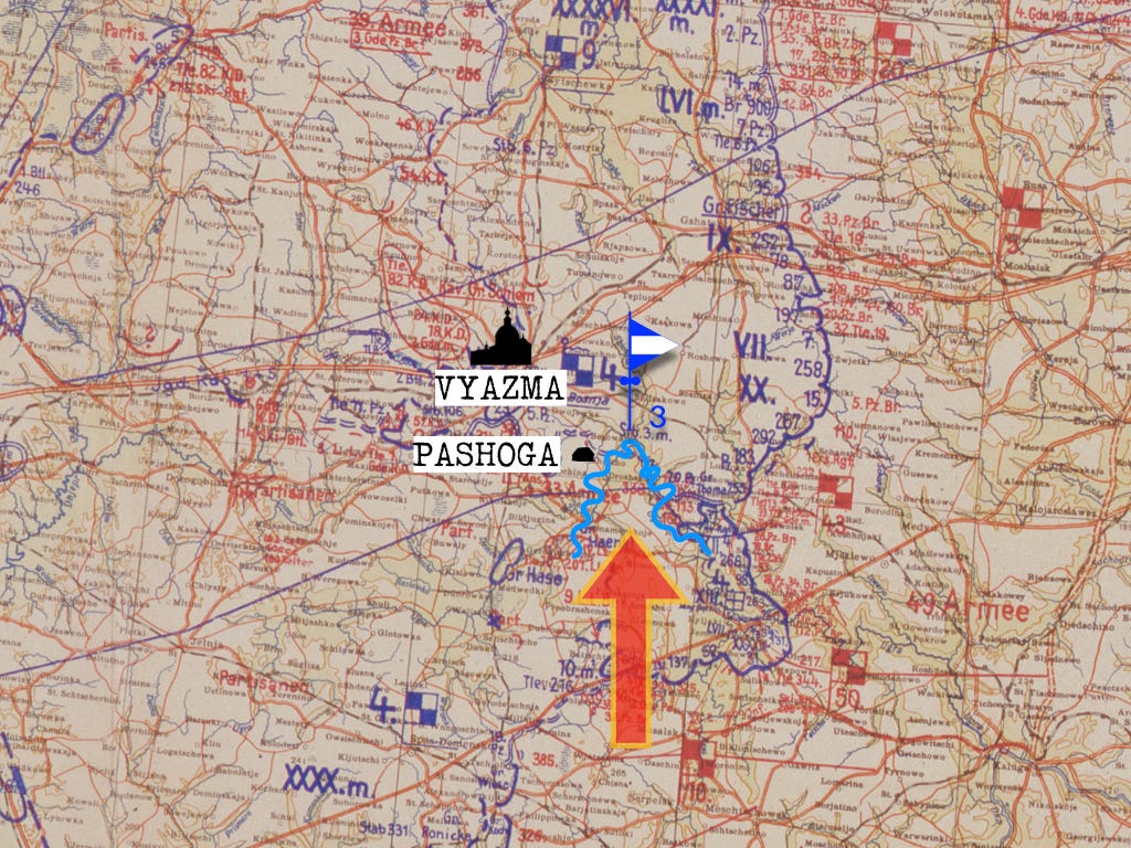
Your boss is also thinking in terms of tactics. Looking at a map of the immediate vicinity of your battalion’s base at Wassilveschina, he notices that a mere three kilometers separates your forces from Pashoga. If, however, you were to attack one of the other Soviet-occupied villages on the west bank of the bend in the Ugra, your battalion would have to walk (or ski) a distance that was twice as long.
Finally, a German force attacking either Tjakino or Stanino would find the Soviet garrison in Pashoga sitting astride the route that connects them to their base.
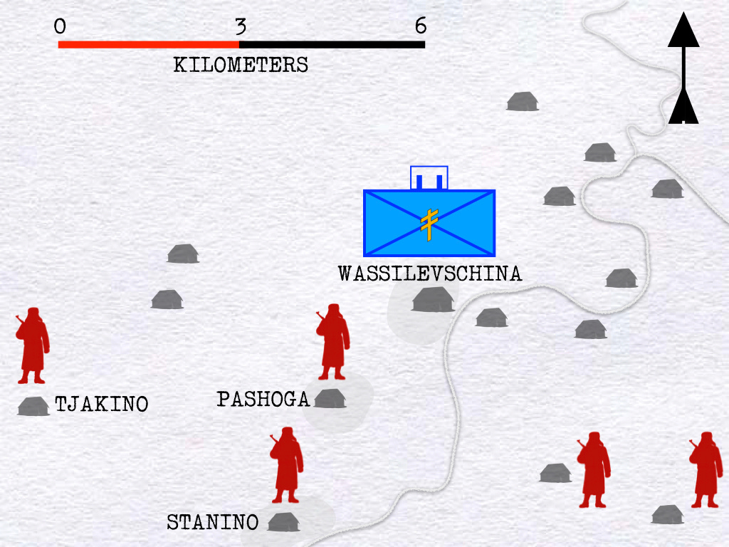
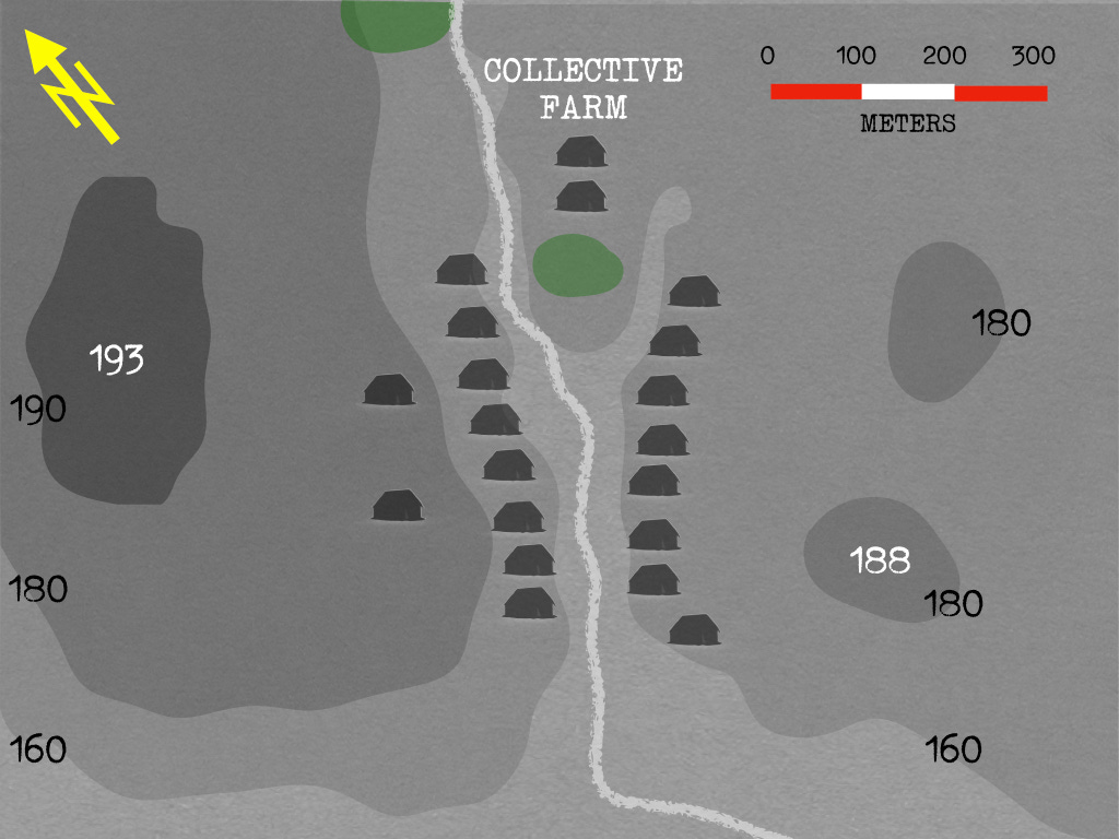
Three sources of useful information - an aerial photograph, a topographic map, and reports of recent reconnaissance patrols - allow you to paint a picture of Pashoga.
Most of the houses in the village can be found on the slopes of a valley formed by a tributary of the Ugra River. The biggest buildings, however, are those of the collective farm for which most of the villagers worked. These are located on a promontory that juts out from the east slope of the valley.
The heights on the west side of the river form a plateau that lies 40 or so meters above the bottom of the valley, which runs some 140 meters above the level of the sea. On the east side of the hollow, the increase in elevation rarely exceeds 20 meters.
On the western heights, a hill - marked on your map as 193 - dominates the surrounding terrain. On the east side, two smaller hills - 180 and 188 - rise above the plateau.
This afternoon, the sun will set at 4:58. Tomorrow morning, it will rise at 6:25.
What, Captain, are your orders?
If you wish to share your solution to this problem, please feel free to use the comment section of this post. In doing this, please explain the reasons behind your decision. When doing this, please refrain from sharing any information that would spoil the problem for your fellow readers.
The next post in this exercise will provide a translation of the orders that Captain Middeldorf gave to his battalion at noon on 27 February 1942.
Move the observers from Battery Pengel along with one rifle company to hill 193 overlooking the village. Move the heavy company and one rifle company to the north of the collective farm preparing for a dawn attack. Final rifle company and recon troops to east of village. Recon company to continue to south closing off encirclement if time allows. Attack at dawn with indirect and direct artillery fire to fix partisans followed by sequenced infantry attacks from north then east then west.